

Eastern Nepal presents an abundance of natural splendor and rich cultural heritage, providing a wide range of experiences for visitors. With its majestic mountains, verdant tea plantations, lively ethnic communities, and tranquil scenery, this area stands out as an enchanting destination. Below is a guide to some of the most remarkable locations to explore in Eastern Nepal. Today we briefly discussed eastern Nepal. Here are some famous places in eastern Nepal.
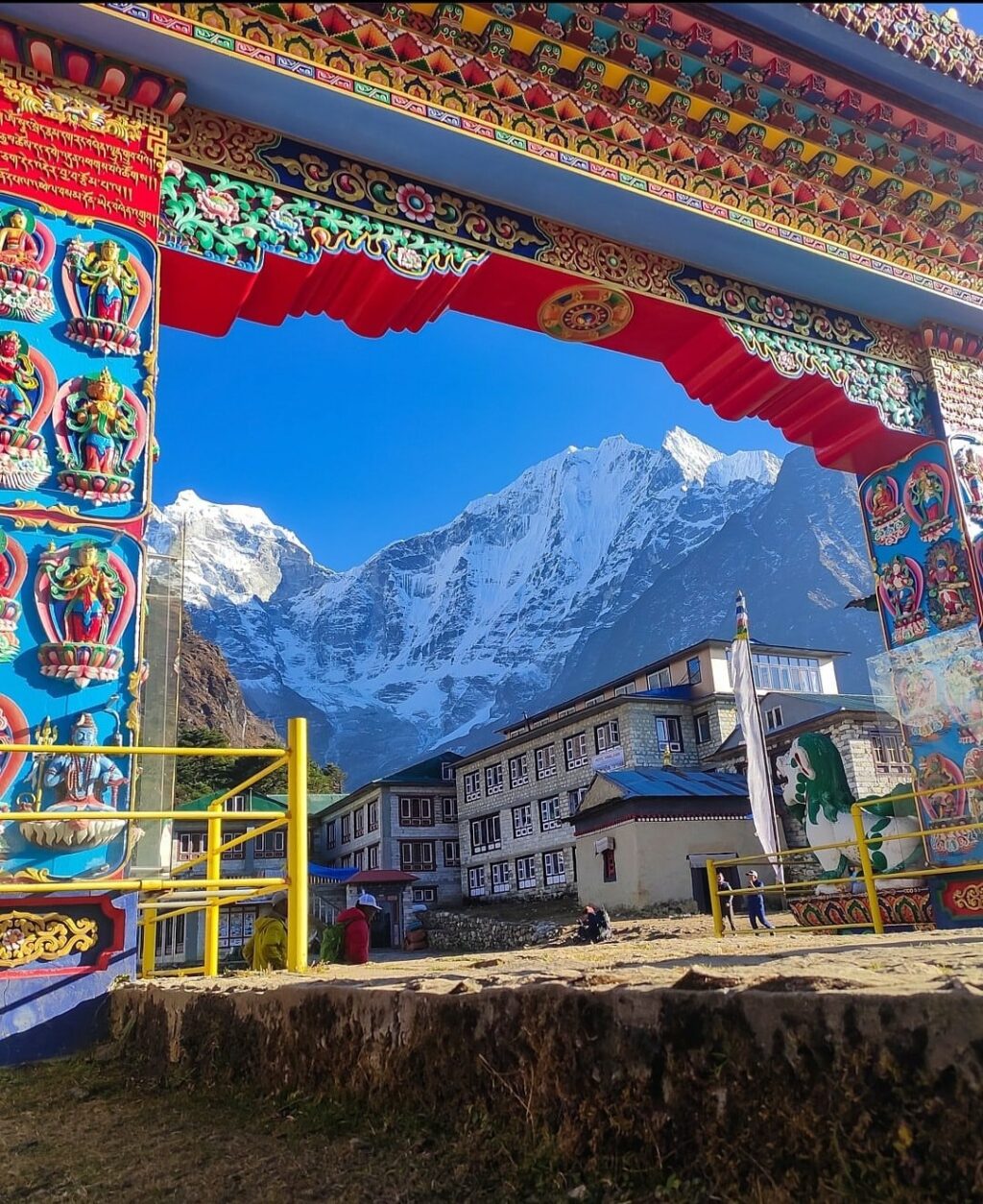
1. Namche Bazaar
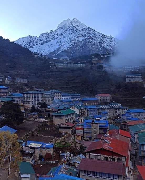
Namche, officially known as Namche Village Development Committee, is a town situated in the Khumbu Pasanglhamu Rural Municipality within the Solukhumbu District of Koshi Province in northeastern Nepal. Positioned at an elevation of 3,440 meters (11,286 feet) at its lowest point, it is nestled on the slopes of a hill. The majority of Sherpas engaged in the tourism industry originate from the Namche region. This town serves as the primary trading center and focal point for the Khumbu area. According to the census, Namche had a population of 1,647 residents distributed across 397 households.
Transport to Namche bazaar.
Situated on a hill that provides a view of Namche Bazaar, Syangboche Airport (3,750 m / 12,303 ft) is no longer operational for passenger services; however, it does see sporadic cargo flights conducted by Russian helicopters. The closest airport currently in operation is Tenzing–Hillary Airport, which is located 13 km to the south of the town.
Tourism in Namche bazaar.
Namche Bazaar is a well-known destination for trekkers in the Khumbu region, particularly favored for altitude acclimatization, serving as the gateway to the majestic high Himalayas. The town offers a variety of accommodations and shops to meet the needs of its visitors, along with several internet cafés. It features German bakeries, quaint cafés, and numerous dining establishments.
Notably, there is an Irish pub, reputed to be the highest and most isolated Irish pub globally. A local delicacy that is quite popular is yak steak. Every Saturday morning, a weekly market takes place in the heart of the village. Additionally, there is often a daily Tibet market where clothing and affordable Chinese consumer goods are commonly available for purchase.
2.sagarmatha Nattional park
Sagarmāthā National Park, located in the eastern Himalayas of Nepal, was established in 1976 and covers an area of 1,148 square kilometers (443 square miles) within the Solukhumbu District. The park’s elevation varies from 2,845 meters to 8,848 meters (9,334 feet to 29,029 feet), featuring the renowned Mount Everest. To the north, it borders the Qomolangma National Nature Preserve in the Tibet Autonomous Region, while to the east, it is adjacent to Makalu Barun National Park. The park’s southern boundary extends to the Dudh Kosi River, and it is recognized as part of the Sacred Himalayan Landscape.
Sagarmatha National Park encompasses the upper catchment regions of the Dudh Kosi and Bhotekoshi rivers, as well as the Gokyo Lakes. The park’s elevation varies from 2,845 meters (9,334 feet) at Monjo to the summit of Mount Everest, which stands at 8,848 meters (29,029 feet). Notable peaks exceeding 6,000 meters (20,000 feet) include Lhotse, Cho Oyu, Thamserku, Nuptse, Amadablam, and Pumori. The park is characterized by barren land above 5,000 meters (16,000 feet), which constitutes 69% of its area, while grazing land accounts for 28% and forested areas make up the remaining 3%. The climatic zones range from temperate and subalpine above 3,000 meters (9,800 feet) to alpine conditions above 4,000 meters (13,000 feet), marking the upper limit for vegetation growth. The naval zone commences at 5,000 meters (16,000 feet).
3. Lukla
Lukla is a quaint town located within the Khumbu Pasang Lhamu rural municipality of the Solukhumbu District in Province No. 1, northeastern Nepal. Positioned at an elevation of 2,860 meters (9,383 feet) above sea level, it serves as a key entry point for visitors heading to the Himalayas, particularly those aiming to reach Mount Everest. The name Lukla translates to “place with many goats and sheep,” although such animals are now rarely seen in the vicinity.
The village of Lukla features a small airport that facilitates access to the region, alongside a range of shops and lodges that cater to tourists and trekkers, offering western-style cuisine and essential supplies for the trails. Travelers departing from Lukla typically require two days to reach Namche Bazaar, which serves as an altitude-acclimatization stop for those continuing their journey. The airport boasts a single asphalt runway measuring 527 meters (1,729 feet), recognized as one of the shortest commercial runways globally.
4. Dingboche
Dingboche is a Sherpa settlement situated at an altitude of 4,410 meters (14,470 feet) in the Khumbu region of northeastern Nepal. As of 2011, the estimated population was around 200, with a total of 32 households. The village experiences a Tundra climate, classified as ET according to the Köppen system. Summers are characterized by cool and rainy conditions, while winters are dry and cold, largely influenced by its elevation and the summer monsoon. For trekking enthusiasts, the optimal seasons are spring (March and April) and autumn (October and November), as these months offer excellent mountain visibility and moderate temperatures. Although trekking is feasible during winter, most accommodations are closed, and the severe cold rarely rises above freezing.
5. Tengboche
Tengboche Monastery, also referred to as Thyangboche Monastery or Dawa Choling Gompa is located in the village of Tengboche within the Khumjung area of the Khumbu region in eastern Nepal. This Tibetan Buddhist monastery serves the Sherpa community and stands at an elevation of 3,867 meters (12,687 feet), making it the largest gompa in the Khumbu region. Established in 1916 by Lama Gulu, it has strong historical ties to its parent monastery, Rongbuk Monastery in Tibet. The monastery suffered destruction due to an earthquake in 1934 but was rebuilt thereafter. In 1989, it faced another calamity when a fire caused significant damage, leading to its reconstruction with the assistance of volunteers and international support.
Nestled within Sagarmatha National Park, a UNESCO World Heritage Site recognized for its “outstanding universal value,” Tengboche Monastery offers breathtaking views of the Himalayan range, including prominent peaks such as Tawache, Everest, Nuptse, Lhotse, Ama Dablam, and Thamserku.
Tengboche serves as the endpoint of the “Sacred Sites Trail Project” within Sagarmatha National Park, drawing numerous tourists interested in trekking and mountaineering. This circular trail encompasses ten monasteries, following a clockwise route that culminates at Tengboche Monastery.
6. Gorakshep
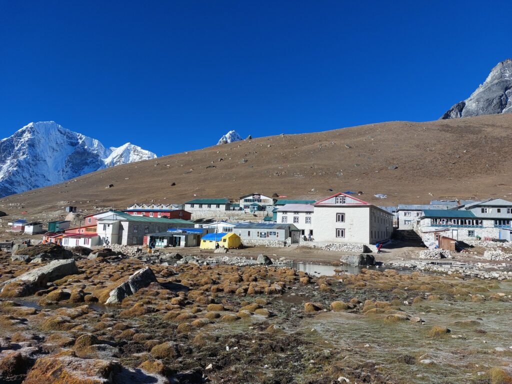
Gorak Shep, alternatively spelled as Gorakshep, is a settlement located on the edge of a frozen lakebed covered in sand in Nepal, which shares its name with the area. Positioned at an altitude of 5,164 meters (16,942 feet) in proximity to Mount Everest, it remains uninhabited for the majority of the year, becoming accessible only during the Mount Everest trekking season.
The optimal periods for trekking are during the spring months of March and April, as well as the autumn months of October and November, when visibility of Everest is at its best and temperatures remain relatively mild. It is important to note that during autumn, there can be significant competition for lodging, leading some trekkers to resort to sleeping on the dining room floor of the lodges.
Trekking is also feasible in winter, from December to February; however, most accommodations are unavailable, trails are often covered in snow, and the cold can be quite severe. The name Gorak Shep translates to “dead ravens,” a reference to the complete absence of vegetation in the surrounding area.
7. Koshi Tappu Wildlife Reserve.
The Koshi Tappu Wildlife Reserve is a designated conservation area located in the Terai region of eastern Nepal, encompassing an area of 176 square kilometers (68 square miles) of wetlands across the Sunsari, Saptari, and Udayapur Districts. This reserve features vast reed beds and freshwater marshes situated within the floodplain of the Kosi River, with elevations ranging from 75 to 81 meters (246 to 266 feet). Established in 1976, it was recognized as a Ramsar site in December 1987. The reserve is notable for being home to the last remaining herd of wild water buffalo (Bubalus arnee) in Nepal.
The reserve’s vegetation is primarily defined by a combination of mixed deciduous riverine forests, grasslands, and marshy areas. Grasslands dominate the landscape, covering 68% of the area, while forested regions account for approximately 6%, with Indian rosewood being the most common species. The northwestern section features more significant patches of catechu forest. The grasslands adjacent to the flowing water bodies are sustained by seasonal flooding and wildlife grazing. The Sapta Koshi River, a tributary of the Ganges, experiences rapid and severe flooding during the monsoon season. Within the expansive wetlands, a total of 514 plant species can be identified, including kapok, sugarcane, reeds, cattails, Imperata cylindrica, eel grass, as well as various species of Eichhornia, Hydrilla, Azolla, and lotus.
8. Gokyo
Gokyo is an antique vill positioned in the Solukhumbu District of Nepal, nestled in the Himalayas at the base of Gokyo Ri and deposited along the eastern bank of the third Gokyo Lake, known as Dudh Pokhari. To the southeast lies the village of Charchung. The geographical equals for Gokyo can be stylishly observed on Google Earth at 27 ° 57 ′ 16 ″ N 86 ° 41 ′ 43 ″ E. This villa is perched at an altitude of 4,750 measures( 15,584 bases), rendering it one of the loftiest inhabited locales in both Nepal and the world. The maturity of the structures in Gokyo serve as guesthouses feeding to pedestrians.
The original occupants generally vacate the villas during the downtime months, shifting to lower-altitude townlets similar to Namche Bazaar. In 1995, a woeful avalanche claimed the lives of 42 individuals, including 17 foreign citizens — 13 from Japan, two from Canada, one from Ireland, and one from Germany. This disaster was rained by a cyclone in the Bay of Bengal, which had deposited 6 bases( 1.8 measures) of snow in the mountainous region the week prior, thereby heightening the threat of avalanches.
9. Phakding

Phakding is a quaint village located in the Khumbu region of Nepal. It is situated in the Dudh Kosi river valley, positioned to the north of Lukla and south of Monjo, at an elevation of 2,610 meters. This area has been recognized as a UNESCO World Heritage Site since 1979. The village is home to approximately 550 residents, primarily from the Sherpa and Tamang ethnic groups. The inhabitants practice Tibetan Buddhism and gather for prayers at a small Gompa located in the heart of the village.
The trekking route commences in Lukla, with Phakding frequently serving as a key rest stop for trekkers en route to Mount Everest, whether via the Gokyo Ri or Tengboche paths. The village’s main purpose is to cater to the tourism sector, featuring a variety of guesthouses. Phakding boasts around 25 accommodations, ranging from simple homestays to four-star luxury hotels, with the capacity to host up to 300 tourists simultaneously.
10. Biratnagar
Biratnagar, a metropolitan city in Nepal, functions as the capital of Koshi Province. According to the 2021 census, it boasts a Metropolitan Urban Agglomeration population of 244,750, making it the largest and fastest-growing city in the province, as well as the administrative headquarters of Morang district. The preliminary report from the 2022 Nepal census estimates the population of Biratnagar Metropolitan at 243,927, not including the well-connected suburban areas surrounding the historic town.
It serves as the administrative hub of the Greater Birat Development Area, which encompasses Biratnagar and its neighboring towns, including Itahari, Gothgau, Biratchowk, and Dharan, primarily situated along the Koshi Highway in Eastern Nepal. The total urban agglomerated population, including the town of Itahari, is estimated to be 804,300 across 159,332 households. Biratnagar is located 399 kilometers (248 miles) east of Kathmandu, the capital, and 6 kilometers (3.7 miles) north of Jogbani, a town in the Indian state of Bihar. It serves as a significant entry point for both businessmen and tourists visiting Nepal for various reasons.
Biratnagar serves as a central point for those seeking to explore various destinations in eastern Nepal, including Ilam, Taplejung, Sankhuwasabha, and Panchthar. Each week, vibrant haat bazaars, or weekly markets, take place in different areas of the town, where local farmers display and sell their agricultural products, spices, and handicrafts. The city is also home to numerous gardens, temples, and sites of religious significance. Notable gardens include Gopal Garden, situated near Hathkhola, and Hridreyandra Bal Udhhyan, located close to Thulo Mill. The temples of Biratnagar are particularly noteworthy, adorned in colorful decorations that enhance their appeal.
Dharan lies 46 km (30 mi) to the north, while Itahari is 24 km (10 mi) away from Biratnagar. These locations are renowned for attractions such as Taltalaiya, Ocean Park, Gokulam Resort, Dantakali Temple, Pindeshwor Temple, Budha Subba Temple, and Panch Kanya. Bhedetar, a hill station, offers a scenic viewpoint. The tea gardens of Ilam are approximately a four-hour drive from the city.
Additionally, the hilly district of Dhankuta, known for its orange orchards, is another point of interest. The Koshi Tappu Wildlife Reserve, favored by bird-watching enthusiasts, is located a 90-minute drive from Biratnagar and is home to the endangered wild buffalo, referred to as “Arna” in Nepali. The expansive rhododendron forests of Tinjure, Milke, and Jaljale can be accessed within 3 to 4 hours, and treks offering views of Mt. Makalu and Kanchenjunga can commence from the small towns of Basantapur or Tumlingtar.